The Dark Heart of Winter

mt a


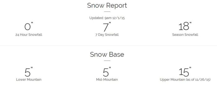
That’s not a snow report, that’s a dull blade shoved in deep. Mt. Ashland has a veneer of snow on her slopes, nothing more. At least two feet of the white stuff, preferably three, is required for skiing. Another winter is upon us and although it is early things are once again starting slowly. Too slowly for my taste. Last year was a disaster and that followed a year that was actually worse. If good things come in threes, what do bad things come in?

I love winter. I love cold weather. Jackets, hats, gloves, scarves, thick socks—these are the things that make me happy. Piles of snow make me even happier. It’s been plenty cold here in the State of Jefferson but there’s certainly not been enough moisture in the air. On our drive south last week we drove over Black Butte Summit in the snow. We followed the plows on the interstate as they scraped the measly few inches off the blacktop in front of us. Since then? Nothing. Bupkes. Nada. Oh, the forecast says we’ll get a drop or two later this week but nothing to get excited about.

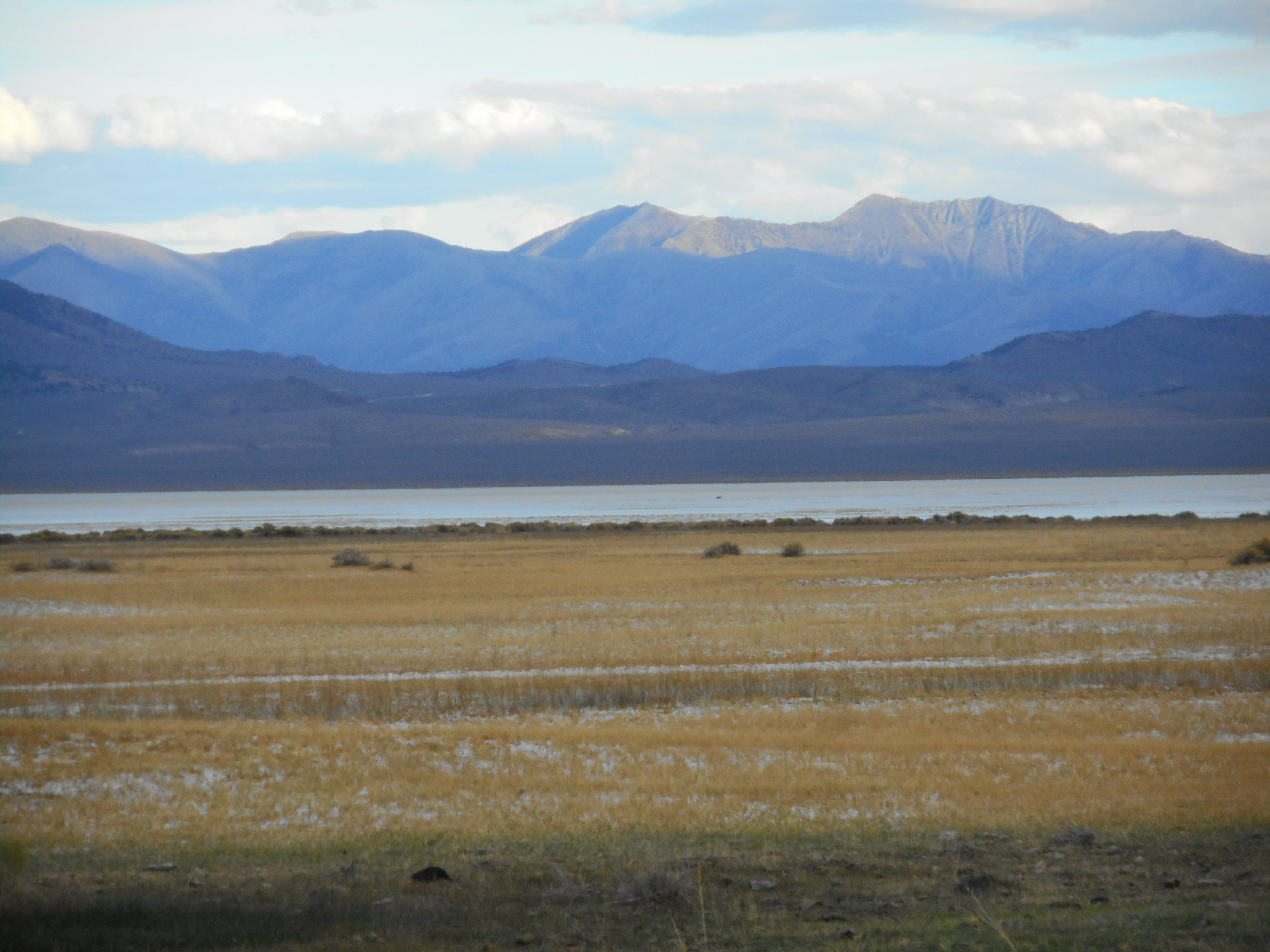
In California we talk about drought all the time. That’s because it doesn’t rain at all for half the year. Just about all the precipitation that will fall in the state will fall between November and April. From May to October we are mostly dry. And half the damn state is desert or damn close. I tell people we will always have drought. We will always demand more water for whatever purposes we want it for and our demand will always exceed our supply. But it can be better some years and worse in others and that is mostly due to snowpack. In fact, the entire California water system is built on snowpack. During the dry season the snow melts and keeps the flow of fresh water coming. No snowpack, no renewal. No replenishing the streams. No refilling the reservoirs. No recharging the aquifers. That’s what we have been experiencing lately. Unless we get a proper snowpack this winter we will suffer again next year.

The water-hungry can be forgiven for their obsession with El Niño. I’m not sure any of us can adequately describe an El Niño, but we will babble on about it and imbue the term with prayerful longing because we are desperate for relief. The rains will come at some point and most of the state will sigh contentedly, sure that it means the drought is over. But the high country folk will look at the snowpack and if it isn’t thickening steadily they will sigh resignedly, convinced once again that the gods of winter have cursed us.

And that’s where I am right now. In the dark heart of winter. I sit, watch, and wait for the storm clouds. I long for masses of saturated Arctic air to descend upon our little valley and the peaks that surround us. I need a sign that such will happen soon or I will be be weeping and gnashing my teeth, wailing and lamenting the cruel and capricious weather deities.

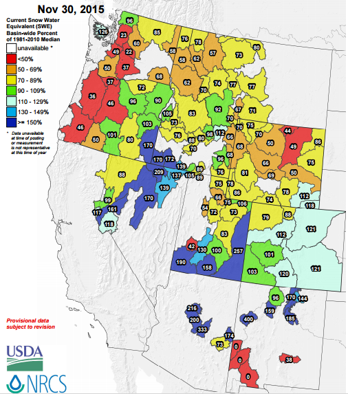
I’ll leave you with this. It’s a map of the West with current snowpack numbers compared to the 1981-2010 median for each region. Green, blue, and purple are good. Red, yellow, and brown are bad. I see a lot of bad. Tell me something good is on the way.


1201_snowpack_map

Burn, Baby, Burn

You can’t “Drill, Baby, Drill” without a few complications and one of the biggest is the low cost of natural gas. We are swimming in the stuff and it’s not always worth it—economically—to collect it and transport it from the wellhead to wherever it needs to go. Consequently we burn a lot of it off. Seems nuts, right? This is a high-quality, relatively clean fuel source and we waste it to the tune of 288 billion cubic feet annually. Is that a lot? The US consumes about 27 trillion cubic feet in a year so the amount that’s leaked, vented, and flared (burned off) represents about one percent. Of that 288 billion about 129 billion cubic feet or roughly 45% comes from North Dakota alone.

exxon-gas-flaring-photo01

On the global scale the natural gas waste is about 5 trillion cubic feet meaning the US is responsible for about 5%-6% of that total. That number is growing, again mostly because of North Dakota. I’m not picking on the Peace Garden/Flickertail/Rough Rider State. We all burn oil. And when you drill for oil you often get gas. And in places where there is an infrastructure to get the gas you get the gas. Where there isn’t you vent it or burn it off. Turns out that methane is a worse greenhouse gas than carbon dioxide so burning it may be the better choice. Regardless, it’s a terrible waste. Here’s part of the reason why (from geology.com):

nat gas price

It costs money to move the stuff. Natural gas (which is mostly methane) is not very dense. It can’t be moved through a pipeline unless it is compressed. It can’t be shipped unless it is liquefied. It’s also quite combustible. This is why gasoline and diesel remain such valuable transportation fuels: they are relatively dense and thus relatively easy to move from one place to another. And they are a lot less combustible, especially diesel. Gases mix with air and ignite easier and burn faster than liquids. Automotive gasoline (petrol) is more volatile than diesel (it fumes easier and makes vapors more readily) and thus is more dangerous to store and carry. This is why we transport crude oil (denser and less volatile than its refined by-products) long distances and refine it closer to the markets. Natural gas also has to be processed—have moisture and impurities removed and any other useful hydrocarbons separated. These things not only cost money but require particular engineering solutions.

Even so, a big rich country like ours ought to not waste a valuable energy resource. In Saudi Arabia they’ve invested billions in schemes to recover the natural gas associated with their oil fields. What they can do, we can do. The difference of course is that their stuff is all nationalized and there is little separation between oil executives and energy ministers. In the States we like the “free market” to make its own rules and we tend to scream and holler about government involvement. Unless of course the government cleans the air, protects the water, and stabilizes prices!

North Dakota, particularly with the emergence of the Bakken shale as a major supplier of crude and now natural gas, has a flaring problem. The infrastructure is not there to take advantage of this abundant fossil fuel. Texas, for example, has a more well-developed gas recovery system in place and does not have the flaring waste issues we see in the north. Naturally there is a tug-of-war going on between the developers and the regulators and at some point the market and the populace and the governments involved will figure something out. Just how much we’ll burn off in the meantime remains to be seen.


Black Magic, continued

Geologic time is another kind of magic. Who can conceive of those extraordinary spans of time? It takes a little over three years to equal 100 million seconds in our everyday existence. Three years worth of seconds is hard to grasp. Now think of those seconds as years. Can you imagine 100 million years? Maybe not, but that’s what the geologists ask of us. When they talk about the Rocky Mountains they tell us that they started growing 70 or 80 million years ago, an event they call the Laramide orogeny. This was after a time when present-day Wyoming was at the bottom of a gigantic inland sea. This mountain-building time lasted perhaps 25 million years. Again, those numbers! The Rockies formed then were high mountains and plateaus interspersed with broad, low-lying basins. Erosion stripped much of it away, and glaciation—very recent—carved the landscape we see today. The marine deposits of the ancient seaway created much of the oil and natural gas that lie under Wyoming. Once the mountains grew, the sea retreated and the basins became inland lakes fed by rivers. The climate was sub-tropical, and many of the basins were vast swamps surrounded by forests of ferns and deciduous trees. Over time these swamps were successively inundated and then buried by sediments. Enormous peat bogs formed, some the size of small states. Bury a peat bog deep enough and long enough and you get coal. Wyoming was the beneficiary of a remarkable sequence of geologic events that created its modern mineral wealth.

wyo geol
From the USGS: http://pubs.usgs.gov/pp/p1625a/Chapters/GS.pdf

Coal, like oil, is amazing stuff. It fired the Industrial Revolution. Once it fueled all of our trains until diesel engines took over. These days it is mostly used to make electricity. According to the Energy Information Administration coal is the source of 39% of our electrical needs. But coal comes at a cost, like all fossil fuels. Coal has to be burned to make heat, the heat needed to make steam and turn a turbine. When you burn something you create waste. Coal makes a solid waste called CCR or Coal Combustion Residue. Some of it is fine material, or ash. There’s also boiler slag and the sulfur-laden materials collected from flue gas scrubbers. It’s a lot of stuff, over 100 million tons per year. Some of it can be used by the cement industry or gathered with gypsum to make things like wallboard. The rest has to be disposed of like all solid waste in landfills. Coal burning creates not only greenhouse gases but persistent air pollutants like nitrogen oxides. Not all the sulfur by-products can be scrubbed from the waste gases and those enter the atmosphere as well.

So what are we to do with this abundant and accessible resource? Obviously we are going to burn it but just as obviously we have to find ways to do it better. To those in the industry new technologies and methods can create “clean coal” which has a nice politically acceptable sound-bite ring to it. Environmentalists say such a phrase is oxymoronic, that coal cannot ever be “clean.” It’s a lot like gasoline. We know that our cars pollute but we keep driving because the costs are dispersed. That is, the impacts on the environment and on our health are spread out over the entire nation and sprinkled amongst us here and there. And we’ve seen the success of the Clean Air Act in places like Los Angeles where the air is cleaner because of the regulations and better automobile engines. It’s not like your neighbor collapses in an asthma attack when you start your car. If he did we might notice the effects of burning fossil fuels.

All extraction industries alter the landscape. That’s another cost. Mostly these things happen far from population centers so we don’t notice. And we live in an advanced country with some government oversight and opportunities for citizens to redress grievances or at least express their concerns. You can imagine the impact of fuel and mineral extraction in places where the ruling classes are insulated from the people and from the consequences of their rapaciousness.

Capitalism depends on growth. If your business isn’t growing you are failing. If we aren’t producing and consuming new products our economy tanks. If we don’t get the returns on our investments we can’t make new investments and the economy tanks some more. All of our politicians talk about growth. It’s a sacred tenet of the American way of life. We must continue to get bigger and better. We know there are limits to growth but we don’t want to hear about them. We just want to keep going. Some day, perhaps, we won’t be able to grow any more and we’ll have to figure out a new way to live. For now though we’ll keep the tanks full and keep cruising. Maybe we’ll see something on the journey that will open us up to new possibilities.

Black Magic

In the early days of electrification there were stories of old-timers who would not stand near outlets for fear of the electricity leaking out and on to them. It is called “current” and it is said to “flow” so it is not surprising they would feel as they did. Many descriptions of electricity concepts involve analogies with water systems—battery voltage as a kind of “pressure” for example, much like a municipal storage tank on a tower. These analogies always fall apart because electricity is not at all like water and to grasp what it is requires an effort of imagination much like wrapping your mind around geologic time. Oh, the electricians will tell you they get it, and the electrical engineers will throw differential equations at you, but that is not what I would call “understanding” electricity. Perhaps a few hundred dozen people in the world can communicate in QED, Quantum Electrodynamics, the contemporary theory that covers electromagnetic phenomena. The rest of us can’t or won’t do the math. I’m happy to think of it as magic. It’s a magic we mortals can manipulate, quite skillfully in fact, but a magic nonetheless.

What’s most magical to me about electricity is how swiftly it overtook our lives. James Clerk Maxwell published his eponymous equations in the 1860s and within twenty-five years Nikola Tesla was demonstrating AC induction motors. Within 100 years the developed world was electrified. Perhaps a billion to a billion and a half people in the world today live without electric power but for those of us reading blogs on Facebook life without electricity is unimaginable. Everything we do depends on plugging in. Safe and reliable electrical energy makes our modern world and our modern way of life possible. Did I mention affordable? Electricity in the U.S. is cheap, absurdly cheap. Right now I pay about 15¢ to the folks at Pacific Power for a kilowatt-hour. That means I can burn ten 100-watt light bulbs for ten hours for a buck-and-half. Or I can run my 300-watt computer continuously for a week, that’s 24/7, for about eight bucks.

I’m astonished and amazed by this. Abundant energy at a very low cost is available to me all the time wherever I go. I need not think about it. But I do think about it, it’s my curse. I think about everything. Here’s what I think: we should all know where our good life comes from. We should know what it takes to live the way we do. And what it takes is an elaborate system of resource extraction, power generation, and electricity distribution. Here’s a map from PacifiCorp, the parent company of our local utility:

power grid

Out in Wyoming in the southwestern corner you might be able to discern a dump truck icon which marks a coal-fired generating station. In this case it is the Jim Bridger Plant in Point of Rocks. Wyoming supplies more coal than any other state, meeting about 40% of the nation’s demand. In the Green River Basin there’s an underground mine—The Bridger—that produces about four million short tons of coal annually. That’s pretty small as the big surface mines in other parts of the state can crank out ten to twenty times that. But it’s enough for PacifiCorp to generate two Gigawatts of electricity, of which half goes to Pacific Power customers in Oregon, Washington, and Northern California. Pacific Power’s total capacity is about eleven Gigawatts so the coal plant represents less than ten percent of their energy portfolio. It’s about the same as hydroelectric which is also roughly one Gigawatt. By comparison PacifiCorp’s Top of the World wind farm (the largest of two dozen such facilities) in Wyoming puts out about 200 Megawatts or 0.2 Gigawatts.

Coal is messy, dirty stuff. Like oil. It’s also abundant. The United States is the Saudi Arabia of coal and Wyoming is the Ghawar Field. With carbon emissions and climate change the hot topics these days coal has lost its allure. But the resource isn’t going anywhere. And it is still the largest source of energy for electric power generation in the world and will remain a valuable part of the mix for the foreseeable future. We may stop demanding coal, but we won’t stop demanding electricity. I’ll take a look at the black stuff in my next post.

Athabasca and EROEI

EROEI is not a Star Wars character but rather an acronym for Energy Return On Energy Invested (also written as EROI). It takes energy as well as capital to exploit a resource. Ideally the resource is valuable enough that the investment of dollars needed to get it is worth it. But what of the energy requirements? How much gasoline, diesel, natural gas, and electricity does it take to get a barrel of oil? And at what point does the energy invested become too much? After the oil peak in the 1970s we have come to rely more and more on improved extraction technologies (e.g., “fracking”) and lower-grade resources like shale and the oil sands. This so-called “tight” oil is increasingly the target of our insatiable lust for the black gold. Think about picking fruit from a tree. You get the low-hanging stuff first, then need a ladder, a bucket truck, or the heart of a daredevil to get the rest. That’s where we are with oil.

In Alberta they mine about two tons of sand to get a barrel of oil. That’s for the easy stuff that’s close to the surface and where they can use open-pit mining techniques. Electric shovels scoop up about 100 tons in one pass and fill giant trucks that can haul about 400 tons to the processing facility. Here’s what the equipment looks like (from the Caterpillar website):

truck and shovel

According to calculations made by J. David Hughes of the Post Carbon Institute (in Drill, Baby, Drill) the EROEI for tar sands oil is about 5-to-1. That’s because the bitumen has to be upgraded—separated from the rock it sits in and and diluted to reduce its viscosity so it will flow in a pipeline. Just digging the stuff up is a 12-to-1 venture, the additional processing to obtain the “synthetic” crude that can be shipped to refineries is where the real cost comes in. Note that I have not looked at economic or ecologic costs, just energy requirements. Here’s a picture of part of the process, a “coker tower” (from the Suncor website), where petroleum coke is extracted and used as fuel:

Cokertowers

So is 5-to-1 a good deal? According to EROI of different fuels and the implications for society by Hall, et. al. the average global EROEI for “conventional” fossil fuels is about 20-to1. So the numbers tell us what we knew intuitively, that the new sources of oil are not as energy efficient as the old ones. This is the thing—our demand is increasing. More and more people in the world want the good life and that good life is energy intensive. Our planet holds, still, enormous resources of fossil fuels. Due to their energy density and transportability these fuels will not be replaced any time soon. But the easy pickings are already picked clean. The stuff we go after now is harder to get and much more expensive. In fact, low oil prices make the exploitation of these resources increasingly difficult. When oil was $100/barrel it made sense to chase after them. When the price of crude drops the economics are hard to justify. Consumers and voters like cheap gas, but that’s short-term thinking. Only when the price of oil is high will North American tight oil, whether from Alberta, North Dakota, or Utah, be worth it.

Junkies know about supply and demand. Addiction is demand writ large. Supply is always a problem and cost becomes irrelevant at a certain point. If you gotta have it you gotta have it. That’s us. We gotta have it. How much are we willing to pay?

Athabasca, Black Gold, and You

A barrel of crude oil is 42 US gallons. About half of that barrel is refined into automotive fuel or what we call “gasoline” in the States and other English speakers call “petrol.” Note that this does not include diesel fuel. Last year Americans burned about 375 million gallons of gasoline per day, or a little more than one gallon per citizen per day. There are about 320 million citizens, and 375÷320 is 1.17, but we’ll round off to “one” for convenience. Still, that’s a staggering number. I can go anywhere from 32 to 40 miles on one gallon of petrol in my Honda and about half that distance in my VW camper.

What’s this got to do with Canada? Just that we import more oil from the Land of the Maple Leaf than from anywhere else. About half of Canada’s total production comes from the Alberta oil sands, some two million barrels of crude per day, and they ship about three million barrels per day to their southern neighbors. That’s right—about three of every four barrels of oil produced in Canada come to the United States. We import about nine million barrels per day total so Canada accounts for a third of our imports. The recent domestic production boom here in the States is pretty close to that, The Energy Information Administration says we are closing in on ten million barrels produced daily, the highest total in thirty years.

So when you burn gas in your car you can assume that half of it is American, half of it is foreign, and of that foreign half a third is Canadian, with half of that from the Athabasca. So, yeah, you are burning the oil sands whether you like it or not.

Like I said before I’ve no intention of getting on a soapbox. You can politicize this stuff all you want, I won’t. I want to know what it takes to live the life I do, the life we all live. We First-World Western Industrial Society People, that is. What we don’t grow, we mine. And oil is one of the things we mine. We dig big holes in the ground, yank the stuff out, and process the shit out of it. That’s something. That’s a hell of an undertaking and I want to appreciate it fully.

I like to spend my time outdoors and I love trees and mountains and birds and rocks and streams and all that stuff. And I burn a hell of a lot of gas getting to places that give me that. Not to mention I live in a rural area far from seaports and factories so everything has to be trucked over an extensive highway infrastructure and supported by a gigantic electric power grid.

I’ll leave you with a satellite photo of a portion of the Athabasca oil sands development (from NASA Earth Observatory World of Change)):

athabasca drom space

Athabasca

Follow the Rocky Mountains north into Canada and they trend westward into the eastern half of British Columbia. The neighboring province, Alberta, shares the range along its western boundary. Head east from there and you enter into a vast country of plains known as the Western Canadian Sedimentary Basin. It is bounded on the east and north by the Canadian Shield, ancient rocks a billion years old that underlie such places as Lake Hudson. In that enormous bowl between the high peaks to the west and the broad plateaus of Manitoba and the Northwest Territories you will find enormous reserves of fossil fuels. The most famous, or infamous if you are an environmentalist, are the oil sands found in the valley of the Athabasca River.

The Athabasca River originates in the glacier country of what is now Jasper National Park. It flows northeast for several hundred miles and empties into Lake Athabasca in Saskatchewan. That lake is drained by the Slave River into the Great Slave Lake and those waters ultimately find their way to the Arctic Ocean via the Mackenzie River. Athabasca is from the Cree language and supposedly describes the mixed willows and grasses of the delta country at the confluence with the Peace River. My late mother-in-law, the artist E.B. Rothwell, was inspired by this region’s native inhabitants and created a triptych of etchings called Athabasca I, II, and III which are similar in style to her Spiritus Loci series. That means “spirit of the place” and you can see something of that from the detail below (Athabasca III):

Athabasca III detail
This is from the right-most panel in the triptych.

The name has always evoked a sense of mystery and adventure for me. It’s one of those places that sounds like a fantasy region, and in fact I thought it was until I got to know my mother-in-law better! She loved the lake and forest landscape of the Quetico-Superior country she grew up near and used it a lot in her work. All of her etchings of natural areas were inspired by real places and she especially loved the ones with poetic-sounding names. Check out Chiricahua, for example.

But this is a noir blog, is it not? I mean it says so in the title: “High Country Noir.” So what’s noir about Athabasca? I don’t see any fedoras or femmes fatale. What’s noir about anything, for that matter? How about the dark heart beating in the human breast? Don’t we all have one? And what could be darker than oil and our industrial society’s addiction to it? Our modern world runs on electricity and fossil fuels. Coal, oil, and natural gas power our generating stations and heat our homes and offices. Gasoline and diesel make our cars, trucks, ships, and planes go. Despite the advances in alternative fuels we are still utterly dependent on the hydrocarbons we extract from fossil plants.

Geologists talk about a time between 300 and 360 million years ago when our oxygen-enriched planet was awash in thick forests, many like the contemporary Amazonian rainforests. They named this period Carboniferous for the multitude of coal beds they found all over the globe which they discovered had similar origins. Coal is vegetation that’s been compressed by layers of sediment and then heated and metamorphosed by the tectonic energy of the earth. Petroleum—crude oil—forms similarly, but is primarily from marine organisms like algae and zooplankton. To find oil you look for ancient depositional features like sea beds and lake bottoms. The province of Alberta was under water in the Cretaceous period or about 150 million years ago. The sediments left behind by this inland ocean were buried, cooked, and shoved northeast by the growth of the Rocky Mountains. Petroleum formed under the ground and as it migrated towards the surface bacterial degradation created what oil folks call bitumen, a tarry, rock-like goop that got trapped in the local sandstones. Hence the current name of the resource, the Athabasca Oil Sands.

The amount of bitumen available in the Athabasca and nearby basins has been estimated to be equivalent to all the existing proven conventional crude oil reserves in the world. The numbers they use are 1.7 to 2.5 TRILLION barrels. Think about that. The current estimate of the entire world’s proven reserves is roughly 1.6 trillion barrels. Saudi Arabia sits on about 16% of that, just for perspective. A “proven reserve” is not the same thing as the total amount of oil but an estimate of what is economically viable and recoverable with existing technology. The Canadians only claim about 15% of the oil sands are commercially utilizable but that is still three-fourths of all the reserves in North America.

The total land area (140,000 sq. km or 54,000 sq. miles) under which these oil sands sit is about the size of Florida and occupies about 20% of the province of Alberta. Now that’s a big project. Only a tiny portion of that resource has been exploited so far but it’s clear that the demand for oil is not slowing down so we should expect more of Canada’s muskeg (peat bog) and taiga (boreal forest) country to be denuded in the never-ending search for new black gold. I’m not picking on our neighbors to the north. We are all part of this desperate hunger, this hopeless addiction to petroleum products. Whatever we do to our air, land, and water is on us—all of us. It is not my intention to preach or argue politics. I’m just interested in energy and resources and what it costs us economically and ecologically to live the way we do. If you are too, stick around, I’ll be posting more on the subject. Food for thought: Americans consume about 7 billion barrels of oil annually. That’s out of a worldwide total of around 32 billion.

Nevăda, part III

Austin, Nevăda sits at 6600 feet elevation on the west slope of the Toiyabes. It is bisected by US 50. The first thing you see when coming in from the west is the Chevron and it was a busy place, filled with RVs and motorcycles. We topped off the tank and drove a short block into town and parked upslope from a bar and diner with a “Hippies Use Side Door” sign. We were pretty grungy after our campout and both of us sport long hair but we braved the front entrance nonetheless. The building was both Old West with its rickety wooden porch and New West with its jumbled pile of used appliances rusting slowly in the sun. The waitress was competent but uninterested and we feasted on excellent BLTs. I ordered the fries which were made from genuine thick-cut slices of potato, not the frozen reconstituted things so often substituted for this iconic American side dish. I also had a Ruby Mountain amber ale which was deliciously refreshing. Beer supply is a necessary limiting factor on camping trips—we’d had our last few the previous evening.

Back down the hill to the east we turned north on Nevada 305 and headed to Battle Mountain. Route 305 connects US 50 to I-80 via the valley of the Reese River. Large working cattle ranches dotted the landscape, solar panels replacing the windmills to pump groundwater. There’s not enough surface water to grow alfalfa but the wide green fields made it clear there was enough of it somewhere. Occasional cattle were seen, we figured most of them were still up in the high country. Stacks of hay were the only relief for a dozen miles on either side of the highway. Numerous east and west trending roads, most of them gravel, branched perpendicularly off the asphalt and headed into the hills. Mining is the chief industry of Nevada and they most likely led to gold, silver, and copper mines and processing facilities. I should say mining ranks second to tourism. Most folks spend their money in Las Vegas and Reno, but a small group of dedicated desert rats seek outdoor recreation in the 7th-largest state. We came to love the solitude and wide-open spaces, and saw enough other dust-coated vehicles laden with gear to know we weren’t alone.

Winnemucca is, by rural Nevada standards, a sprawling place and we picked the western edge of town for our lodgings. The showers were hot and the towels plentiful in the Best Western. We had a superb filet mignon in the Winnemucca Inn next door and retired to our king-sized bed to watch the Dodgers lose to the Mets in Game Five of the NLDS. The next day we topped off the tanks and checked the air in the tires (they were all at proper inflation despite banging around on rocky, rutted roads) and looked for US-95, the road to Boise. It took two trips back and forth on the interstate before we found the right exit and the circuitous path through the downtown area to connect. Our destination was Denio Junction, just south of the Oregon border. The countryside was broader and emptier than where we’d been, and when we connected with State Route 140 we were warned with a sign reading “No Services Next 150 Miles.”

140 took us across the northwest corner of the state and into southeastern Oregon. The further west we went the sparser and bleaker the landscape became. Now we were in the volcanic country of high plateaus and jagged ridges of blocky lava. We climbed the Doherty Slide which had 8% grades on the downslope and looked upon a moonscape, an alien, almost Martian scene of geologic turmoil and destruction. Immense fields of lava and volcanic ejecta buried hundreds of square miles some time in our distant past and the plucky desert plants that carved out their existence looked tired and forlorn. It was, literally, the middle of nowhere. The highway was surprisingly busy for such a remote and empty place. Don’t break down on 140 unless you have a lot of time. Fortunately our 1999 VW Eurovan was in tip-top shape after a summer of trips to the mechanic and we sailed along confidently, although mute in wonder and awe at the vast and lonely terrain.

Our final stop was Lakeview. This little town had a prosperous and lively feel to it. The few motels were mostly booked due to construction projects in the region and we were lucky to snag a room. We walked around both in the evening and next morning, enjoying the mix of old and new buildings. We had dinner at a Chinese place. Every town of any size in the American West has at least one Mexican and one Chinese restaurant. Lakeview is the county seat and it sports a modern library, always a good sign. The high elevation regions on either side are mostly Winema National Forest and the tall pines were a welcome sight. We drove home via Klamath Falls and US-97. After a week of arid climes we were surprised by the rainfall that pelted us most of the way, but it sure felt good. It seemed like a good soaking, but the vehicle was still filthy when we made it back to Yreka. Rain in the West is almost always an illusion, even heavy downpours disappear and dry up quickly. It’s the snowpack that makes life possible, and that’s been an iffy thing lately. Perhaps this winter we’ll finally get our regular allotment and not only will ski season be more fun but next summer and fall will be lusher and greener.

Thanks for reading!

Nevăda, part II

We left Nevada Route 722 and took the Elkhorn Road (022) up and over a spur of the Shoshone Range and down into the Reese River Valley. Turning south we quickly came to a road sign listing San Juan and Washington Creeks (016) and we took that for about six miles to a primitive camp site in section 29 at the foot of the Toiyabe Range. It was a dusty and forbidding place, deep in a canyon, so mornings were cold until the sun could pop out from behind the high ridges. Afternoons were unusually hot but with the shadows forming early and the sun disappearing as well the evening temperatures dropped precipitously. All of us were constantly adding and shedding layers. The campsite was flat and luckily large enough for our party of eight. It had one table and an outhouse which proved to be handy as the thin, rocky soil wasn’t conducive to digging a latrine. We spent our days exploring the creeks and hiking up into the higher reaches. Several parties of deer hunters passed by each day, we encountered a couple on horseback in the high country and others passed the campsite in pickups and on ATVs, none looked successful. We saw little sign of their prey, I imagine the drought forced the poor creatures into even higher and more inaccessible spots. Signs of cattle were everywhere though we only bumped into a few cows on the trails. Their droppings were all over, some dry and flaky like cardboard after a few years in the arid climate. Others were fresh. A little bit of livestock goes a long way. The acreage they have to roam to get enough grass must be enormous.

The relatively sparse vegetation and numerous outcrops of jagged, weathered rock on the hillsides gave the place the feel of a ghost town. In those old mining camps nothing is rebuilt and everything eventually decays but slowly due to the lack of moisture. You don’t get a sense in these mountains that geologic activity is happening. It just seems like the landscape is there and that it will eventually erode and fade away. Nothing could be further from the truth. The Basin and Range is quite active and even youthful by geologic standards. There’s just something about the emptiness and lack of obvious activity that makes you think the place is static. Everything of course is dynamic, moving through time and space continuously and subject to the vagaries of entropy. The Basin and Range is no exception and when you add in the roiling and furious energies from the mantle, far beneath the crustal layer, and think in terms of eons and not mere human decades you suddenly see a chaotic, vibrant, and even violent terrain. In geology, “terrain” is the visible countryside with all its features. To include what’s underneath, what creates and shapes the terrain, you use the word “terrane.” The terrane becomes manifest in the terrain if you see with the eyes of a geologist.

Imagine a half-inflated balloon. Now smear chunky peanut butter on it, a nice uniform layer. Inflate the balloon fully. The crust of peanut butter, forced outward and upward by the exapnsion, cracks and splits and separates. The ranges are the strips of peanut butter, the gaps between them the basins. The outward spreading of the crust due to the mysterious tectonic forces in the mantle below created the basin-and-range topography. The mountains eroded to fill the basins but the orogenic processes continued (and continue to this day) and more material was uplifted to be eroded again. At the bases of the mountains you see evidence of erosion in the broad alluvial fans and outwashes. It’s hard to think in terms of mountain-building as these things happen on a time scale too big for our feeble mammalian brains which can handle perhaps a few human generations in either direction, but you have to do it to see the big picture. What you can actually see in country are faults where the big blocks of crust were thrust upward so they could later tilt and topple. And you can also see actual real-time evidence of magmatic heat in the form of thermal waters and hot springs. These pieces of the puzzle tell us that Nevada is a hot place, busy with subterranean rumblings and ready to rumble and shake and upthrust massive hunks of earth just like in earlier epochs.

We spent four nights at the campsite along the creek. Then half the party headed home and four of us spent an extra night retracing our route back to Nevada 722 and into an adjacent, parallel valley to the west, that of Smith Creek. Seven or eight miles north along the road beside Campbell Creek takes you to a hot springs area. Along the edge of the dry lake bed were several hot springs, one had been piped into a large circular cattle trough. Coming out of the pipe the water was too hot to touch, but the filled metal tank cooled to around 90 or 95 degrees Fahrenheit, good enough for a relaxing soak, but not quite hot enough for the therapeutic effects. We camped in the open country in the sparse desert grass that had magnificent vistas of the many ranges near us. One nice thing about the desert regions are the lack of annoying insects. Very few flies and no mosquitoes to pester us while hanging out. The cool fall weather played a part, too. A coyote wandered around while we stayed, mostly keeping his distance and acting like he couldn’t see us. He looked well-fed and had a rich, tawny coat and sported a thick, bushy tail. Ranchers aren’t keen on these characters but we thought he was beautiful. Flocks of horned larks buzzed about regularly and killdeer greeted us in the morning with their distinctive whistling calls. I saw a prairie falcon circle our camp in low ovals, spooking the little guys for a bit, but he cruised off in search of better hunting after few minutes.

hot springs

After five days of camping we decided to hit the road and parted from our friends while a dust storm gathered over the playa. We cruised back north on 722 to Austin for lunch, and then hopped on Nevada 305 for the long drive along the Reese River to Battle Mountain, and thence on I-80 to Winnemucca. I’ll cover that part of the trip in my next post.

Nevăda, part I

There’s a link on the Nevada Department of Transportation’s website you can click to request a state road map. Now I love paper maps, the digital versions just cannot compare, so naturally I ordered one before our trip to the Silver State. The map makes a point to include the breve accent mark over the first “a” in the name, namely “Nevăda.” That’s because Nevadans rhyme the second syllable with “bad”. It may originally be a Spanish word but it’s spoken with an American flavor. Much like Californians say “san-azzay” for San Jose and not “sahn-hoesay.” The word means “snowy” and thus we can see why the mountains that mark the western terminus of the Great Basin are called the Sierra Nevada. I’ve been through Nevada in the winter, and they get some snow, but it’s not the most appropriate descriptor. The state averages less than a foot of the stuff annually, and only eight inches or so of rainfall. Most of that falls on the high mountains, of which there are many. Had I been a Spanish explorer I would have called the place “desierto” or “malpaís” or something to indicate the unrelenting aridity and rugged topography. Maybe the conquistadors were stuck in a blizzard one winter and could think of nothing else.

Nevada lies wholly within the physiographic region known as the Basin and Range Province. Dozens of mountain ranges, mostly running in a north-south direction, cover the entire state. All are about a mile higher than the surrounding lands which are mostly broad, flat valleys, many of them dry lake beds. The plains, or basins, are from 4000 to 5000 feet above sea level. They tend to be no more than a few dozen miles wide but three of four times longer. Imagine a giant hand making scratches in the desert sand, pushing up long, thin peaks between the fingers and gouging troughs between them and you get some idea of the landscape. A drive eastward on I-80 from California does not give you the full picture as it follows, for the most part, the Humboldt River. However looking left and right from the car you can see numerous examples of the ranges and their corresponding basins. You do climb up out of Winnemucca and drop down only to climb again before Carlin and Elko, and then again after Wells before dropping and crossing the border into Utah. But to really experience the unique terrain you have to leave I-80 and take US-50 which bisects the state from the southern tip of Lake Tahoe in the west to Great Basin National Park on the eastern edge.

On our recent adventure we left I-80 at Fernley to pick up US-50 and we stopped in Fallon for gas. This is a good thing to do in Nevada. Always stop for gas and keep your water and other supplies well-stocked. People are generally friendly, and will help a driver in distress, but distances are vast and outposts of civilization few and far between. We headed east towards Austin but ventured off the highway near Eastgate to pick up Nevada Route 722. This well-maintained gravel road climbed the Desatoya Range at Carroll Summit, dropped into the basin, and then climbed the Shoshone Range at Railroad Pass before dropping into the Reese River Valley. The Reese is a big stream by Nevada standards and the Valley supports a surprising amount of cattle ranching. It runs north and empties into the Humboldt near Battle Mountain. The Humboldt, like all Great Basin watercourses, disappears into the sere landscape further west. Hydrologists call this an endorheic watershed, meaning one that has no outflow to external bodies like the Pacific Ocean.

Our destination was the Toiyabe Range on the eastern edge of the Valley. The mountains had an abrupt fault scarp on the west face, reminiscent of the west side of the Wasatch Range near Salt Lake City—which marks the eastern terminus of the Great Basin. The Toiyabes are mostly a pinyon-juniper woodland, with single-leaf pinyon pines (P. monophylla), Utah juniper (J. osteosperma), and mountain-mahogany (Cercocarpus ledifolia) the dominant evergreen species. The open areas are mostly waist-high sagebrush and their rich aroma fills the air. But we were there for the fall colors and the deciduous tree that produces those displays is the widespread Quaking Aspen (Populus tremuloides). In this country the aspens are found in riparian zones which as you can imagine are narrow bands in ravines, canyons, arroyos, gullies, and draws that contain the sparse watercourses. Willows and cottonwoods share the space, too, but they don’t have the same visual appeal. With its flat petioles the leaves of the aspen wiggle oddly in the slightest breeze and when an entire grove gets to trembling at once it’s quite a sight. With the onset of autumn the greens turn to yellows and deep, almost-red oranges and the displays are spectacular especially in the sea of olives, celadons, duns, greys, ochres, and earth-tones that most of the countryside sports.

East-coasters may not think much of fall colors in the West as they are spoiled by breathtaking swaths of maples, hickories, beeches, birches, ashes, and whatnot. Our region is not famed for autumnal richness, but that’s what makes these patches in the arid highlands so appealing—their scarcity. On our hikes up San Juan and Cottonwood Creeks we thought of the aspen groves as plentiful and enjoyed a marvelous palette. Alas, I was too busy staying hydrated in the surprising heat to bother with photographs. You’ll just have to go yourself and see. I do have a photo of the Toiyabes from the Smith Creek Valley just to the west:

Toiyabe Range

That’s enough for today. I’ll cook up part II soon and continue our story.